
The Pole Shift and Planet-X (Nibiru) Research:
Planet X to Eclipse the Sun in 2017-Come into View When the Great Sign Appears Published on Jul 20, 2017
Full interview with David Meade, author of Planet X-The 2017 Arrival.
The Nibiru cataclysm is a supposed disastrous encounter between the Earth and a large planetary object (either a collision or a near-miss) which certain groups believe will take place in the early 21st century. Believers in this doomsday event usually refer to this object as Planet X or Nibiru. The idea that a planet-sized object will collide with or closely pass by Earth in the near future is not supported by any scientific evidence and has been rejected by astronomers and planetary scientists as pseudoscience and an Internet hoax.[2][3]
!!!!!! NEW !!!!!Earth Tilting to the South-Axis of Rotation off Balance-Oceans in Opposition: Sky Watch Media News
There have been many bizarre events that have happened since the time of the Grand Eclipse of August 2017 suggesting that the great spectacle in the sky was, in fact, the precursor to a sequence of horrific events that will come upon the earth in what we now call the latter days.
The idea was first put forward in 1995 by Nancy Lieder,[4][5] founder of the website ZetaTalk. Lieder describes herself as a contactee with the ability to receive messages from extra-terrestrials from the Zeta Reticuli star system through an implant in her brain. She states that she was chosen to warn mankind that the object would sweep through the inner Solar System in May 2003 (though that date was later postponed) causing Earth to undergo a physical pole shift that would destroy most of humanity.[6] The prediction has subsequently spread beyond Lieder's website and has been embraced by numerous Internet doomsday groups, most of which linked the event to the 2012 phenomenon. Since 2012, the Nibiru cataclysm has frequently reappeared in the popular media; usually linked to newsmaking astronomical objects such as Comet ISON or Planet Nine. Although the name "Nibiru" is derived from the works of the ancient astronaut writer Zecharia Sitchin and his interpretations of Babylonian and Sumerian mythology, he denied any connection between his work and various claims of a coming apocalypse.

Zecharia Sitchin and Sumer[edit]
Although Lieder originally referred to the object as "Planet X", it has become deeply associated with Nibiru, a planet from the works of ancient astronaut proponent Zecharia Sitchin, particularly his book The 12th Planet. According to Sitchin's interpretation of Babylonian religious texts, which contradicts conclusions reached by credited scholars on the subject,[24][25] a giant planet (called Nibiru or Marduk) passes by Earth every 3,600 years and allows its sentient inhabitants to interact with humanity. These beings, which Sitchin identified with the Annunaki of Sumerian myth, would become humanity's first gods.[26] Lieder first made the connection between Nibiru and her Planet X on her site in 1996 ("Planet X does exist, and it is the 12th Planet, one and the same.").[27]
However, Sitchin, who died in 2010, denied any connection between his work and Lieder's claims. In 2007, partly in response to Lieder's proclamations, Sitchin published a book, The End of Days, which set the time for the last passing of Nibiru by Earth at 556 BC, which would mean, given the object's supposed 3,600-year orbit, that it would return sometime around AD 2900.[28] He did however say that he believed that the Annunaki might return earlier by spaceship, and that the timing of their return would coincide with the shift from the astrological Age of Pisces to the Age of Aquarius, sometime between 2090 and 2370.[29]
Nibiru-Nemesis System Interacts with the Sun- 2017 Eclipse Becomes Harbinger of Portent for America
On August 21 millions of Americans witnessed a great solar eclipse that extended for several hours across the heartland of the United State. Many who saw that grand spectacle in the sky commented that they had felt quite strange, a strong feeling of apprehension at the moment that the moon was crossing in front of the sun. What was it about the eclipse that seemed to have so many observers feeling uneasy? In the days following the eclipse, extreme weather events happened on a global scale that would have devastating effects on millions of people from Texas to Southeast Asia. It is hard to ignore these events when considering the extreme nature of their occurrence. Skywatch Media News-The Best Source for Alternative News on World EventsStopped Rotation
Prior to the shift, the Earth slows in its rotation, and actually stops. This is recorded in written history and spoken folklore, worldwide, as a long day or night. The explanation for slowing rotation resulting in a stopped rotation during the week prior to the shift is that the passing planet grips the Atlantic Rift magnetically, so the Earth does not turn past this grip.
Last Updated December 24, 2002
This part of the globe is centered between land masses that are fairly neutral in magnetic polarization, but lines up over former lava flows from the renting apart of the continents, the mid-Atlantic rift. The Pacific trench lies deeper under the water and its characteristics differ in composition from the newer magma that has arisen during continental drift.
Thus, the Atlantic lava beds are gripped, facing the Sun, facing the approaching planet coming up from the South along the rift, and causing both Europe, the Americas, and Africa to be on the long day side of the Earth.
Atlantic Stretch
The Atlantic has clearly been stretched and ripped in the past, with shorelines on both sides of the Atlantic being dragged down such that the remains of forests can be seen underwater off the East Coast of the North American continent, and buried roadways under the waves near Bermuda, and likewise land shelves west of the British Isles. The Atlantic Rift, running the entire length of the Atlantic between the present poles, shows recent tears, and in Africa the rifts increasingly separating the Arab lands from the continent proper are already showing some stress.
During the week of rotation stoppage, however, this is extreme, so that the Atlantic Rift is under a great deal of tension and the shorelines are drawn down along both sides of the Atlantic. Europe and Africa are continually pulled eastward, by the rotating core. Thus, the Earth moans in her agony, during this week.
Pacific Compression
Along the Pacific Rim, plates are being pushed under the Americas, and creating distress in Indonesia as compression of the Pacific is already in process from prior pole shifts and subducting plates are inclined to continue this momentum. The Himalayas, driven high from sea bed material in the past, also show a point of drama, already scripted for India and Australia by past dramas which positioned these plates thus.
Quakes all along the west coast of the Americas increase, and volcanic activity in Japan and Indonesia become extreme. India shutters, jerking under the Himalayas in spurts, creating great panic among her peoples who are already fearing the worst with the long evening they are experiencing. Tidal waves are not yet a problem, as the waters normally pooling around the equator have equalized around the globe, more water at the pole and less in the equatorial regions.
The dusting with red dust should be considered a warning to take cover, under metal or sod roof structures, out of the wind. The shift cannot be more than a few hours away. The dusting with red dust occurs less than 24 hours, and most likely less than 12 hours.
This depends upon a number of factors, including how well the dust drops through the atmosphere to be deposited on land where the very first evidence will be closely watched for and thus observed. In one location, the first sign of dust may be 18 hours ahead of the shift, and all run in panic to shelters. In another location, dust may not be noticed until heavy, perhaps 6 hours ahead of the shift, a good time to head for the shelters in any case.
The tail sweep will then proceed from red dust to hail stones just ahead of the shift. A normal roof would protect from the hail stones, which will be like the hail experienced during violent windstorms, where hail of ice falls and ruins crop.
Pole Shift
There is a great deal of tension that builds between the crust of the Earth and the core of the Earth during the week of rotation stoppage. This tension is released when the core of the Earth breaks with the crust, and moves. However, the core of the Earth drags the crust with it. The pole shift is therefore sudden, taking place in what seems to be minutes to humans involved in the drama, but which actually takes place during the better part of an hour.
There are stages, between which the human spectators, in shock, are numb. At first there is a vibration of sorts, a jiggling, as the crust separates in various places from the core. Then there is a Slide, where the crust is dragged, over minutes, to a new location, along with the core. During the slide, tidal waves move over the Earth along the coast lines, as the water is not attached and can move independently.
The water tends to stay where it is, the crust moving under it, essentially. When the core finds itself aligned, it churns about somewhat, settling, but the crust, more solid and in motion, proceeds on. This is in fact where mountain building and massive earthquakes occur, just as car crashes do their damage on the point of impact, when motion must stop.
Hurricane Winds
During the shift, the atmosphere of the Earth does several things, all at once. It drags along with the Earth. It moves as a mass, pushing on air in other places. Thus, even in those places on the Earth which are not moving, during the shift, being pivot points, the air is turbulent. It swirls, as circular motion in air masses is the response to conflicting forces, as seen in the circular motion of tornadoes and hurricanes.
One should not assume a force of winds above what the world experiences today. Your hurricanes and typhoons represent what occurs when air masses attempt to move against each other, given their density and gravity attraction and inertia. These same factors are in place, are predominant, during the pole shift. Stay below the Earth’s surface, lie low, and tie down everything you wish to find when it’s over.
Earthquakes
Tearing of continents is less traumatic than it would seem to humans, who imagine the continents as one plate and think of how lumber resists being torn, metal bends and twists before tearing, and a rope of fibers resists while the fibers snap one by one. Continents are in fact an overlay of many plates, and faults are where most of the plates have fractured in the same place. The continents are attached because some of the plates have not fractured.
Thus, ripping apart of continents is no more traumatic than subducting or slip-sliding. The land along the edges generally retains its altitude, as this was determined by the thickness of the plates, thus its buoyancy on the sea of lava. Solid land is composed to a great degree from the lighter elements, which rose to the top during the early cooling of planet Earth, and thus formed the floating crust.
Mountain Building occurs during rapid subduction of one plate under another. There is friction between the plates, so that crinkling of the upper plate occurs. This crinkling represents pressure and release, which can result in violent jerking and upheavals, sometimes snapping to create new cliffs or jutting rock. Those riding on the upper plate during these moment will be heaved skyward and dashed, with scarcely a safe place to cling to. Subduction can release pressure by pushing flakes of land that separate from lower stratas forward.
This thrust can be sudden and projectile, with the rock flake then crashing down again. Pressure and release can also create crumpling land where such activity is not expected. Compressed rock can also drive horizontally, into nearby soil or space not occupied by anything as dense as itself. Thus, those in a valley can find rock shooting out of a hillside, or rock spears shooting under their feet, unexpectedly. Surviving the mountain building process while in the mountains is precarious, and not advised.
Firestorms
During the comet’s passage, there is such an onslaught to the Earth’s upper atmosphere that the available oxygen in places is completely consumed. Heated gas in the comet’s tail form petrol chemicals due to the flashes of lightning and intense heat due to passage over open volcanoes, and these petrocarbons rain down, a sheet of flame falling to Earth.
With the atmosphere scattered, these petrol chemicals descend close to the surface of the Earth before bursting into flame. A fire storm, killing all beneath it. All this has been reported in ancient times, as humans observed accompaniments to the cataclysms. This type of activity sets forests afire. Where vegetation re-grows, from seeds and roots, many areas will nevertheless be denuded of vegetation for some time.
Flood Tide
During a pole shift, the ocean as a whole is on the move because it stays behind while the crust moves, and thus rolls up on land onto the coastline being pulled under it. This is a flood tide, with the lip of the water being its highest point, rising like a silent tide endlessly on the rise, the wave rolling inland without a crashing back and forth, just a steady progressive inundation. To those at the mercy of such a flood tide, their first thought is to climb above the tide. Soon they are standing on the highest point they can reach, and still the water, flowing inland steadily, rises.
Afloat on a boat or flotsam, they will be dragged inland with the flow until a reverse slosh begins, the water flowing back into its bed but in the nature of water during a slosh, overshooting this other side so that both sides of the ocean experience this flood tide, alternately, for some days until the momentum diminishes. When the flood tide recedes, those afloat are in danger of being dragged far out to sea with the flow, as the water will rush to its bed unevenly, more rapidly where it can recede the fastest.
Where tidal waves meet mountains, this can result in tidal bore up ravines. Where tidal waves flow inland, this results in a flood tide going hundreds of miles inland. Where the Atlantic widens and tears apart the North American continent along what is already her sea-way, there will be more places for the water to pool than water available, and this will cause a rushing toward this part of the globe by water gathered at the poles.
There will be a temporary lowering of water in the Indian Ocean, which will draw water from where it has gathered at the South Pole. Where the Pacific shortens dramatically, the water in the Pacific will find its bowl suddenly smaller, and will rise along shores on both sides. Given the size of this ocean, and the ability of her waters to rush over low-lying areas in Central America or around Australia, tidal waves along the Pacific coast are not substantially larger than along other coasts.
A Scripted Drama

Back to Contents
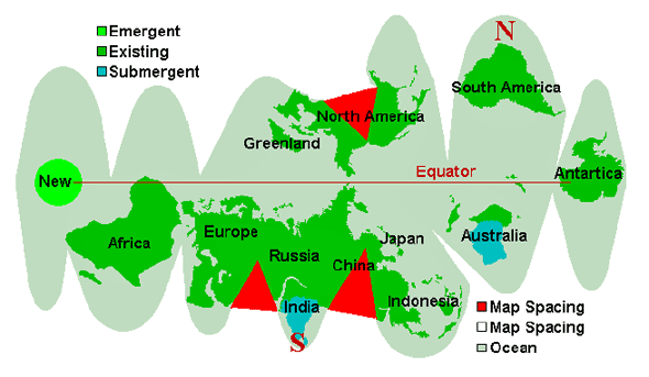
- As the South Pole, gripped by the passing North Pole of the 12th Planet, moves north, the crust is torn from the core and freed in this way, allows pre-existing stress points to relax. Thus, Europe and Africa move further east, allowing the Atlantic to rip apart, during the slide northward.
- The immediate affect of the massive plate housing Europe and Russia and the Near East to move is felt most strongly in India, as the Himalayas are driven over India at this point, effectively submerging this country in a wink.
- The effect of the Indio-Australian plate taking a dive under the Himalayas is to relieve tension along the African rift, such that this tears, promptly, but in shuddering steps with halting adjustments pauses between shudders. In essence, the movement eastward of the African continent is a momentum creating this tear.
- During the tearing of the Atlantic, and the dragging north or the North American continent, an already existing tear in the St. Lawrence Seaway tears further, essentially the weak link in this landmass held at so many points to the further side of the Atlantic. Canada move north, while the rest of the Americas cling to the Atlantic Rift while it separates.
- The movement of the massive plate housing Europe, Russia, and Asia to the east also is expected to rip this plate along the Himalayas, as we have stated, creating an inland bay into the Russian lands just to what is now the north of the Himalayas. This follows, in jerks and tears, over the hour of the shift, along with the tearing of the African rift.
- When the ocean off the Bulge of Brazil has reached the position of the current North Pole, crust slippage stops, creating yet another drama. The major northern hemisphere plates stop, and whatever follows crashes into them. In the case of the America’s, this causes Central America and the Caribbean to crumble.
- In the case of Africa, already sliding eastward, the force is further movement eastward, as subduction of the Indio-Australian plate has already begun, the weaker link already established and momentum in process.
- The pile-up is in what was the former northern hemisphere, and the compression of the Pacific is creating resistance as plates are subducted under the Americas and Japan explodes and Indonesia crumbles.
- This frees the plates south of the tips of South America and Africa of stress. As the Pacific adjusts, reluctantly, pressure toward Antarctica, the one place on the globe not experiencing plate pressure, allows new land to pop up between the tips of South America and Africa.
The coming pole shifts and what Edgar Cayce had to say about them
The cataclysmic pole shift hypothesis suggests that there have been geologically rapid shifts in the relative positions of the modern-day geographic locations of the poles and the axis of rotation of the Earth, creating calamities such as floods and tectonic events.
There is evidence of precession and changes in axial tilt, but this change is on much longer time-scales and does not involve relative motion of the spin axis with respect to the planet. However, in what is known as true polar wander, the solid Earth can rotate with respect to a fixed spin axis. Research shows that during the last 200 million years a total true polar wander of some 30° has occurred, but that no super-rapid shifts in the Earth's pole were found during this period. A characteristic rate of true polar wander is 1° or less per million years. Between approximately 790 and 810 million years ago, when the super-continent Rodinia existed, two geologically rapid phases of true polar wander may have occurred. In each of these, the magnetic poles of the Earth shifted by ~55°.
Please visit our friends websites it's amazing stuff,
United States
The mountains on the West Coast of the US in general will be hot and rugged, with much upheaval, during the shift. The Sierras have been created because of subduction of Pacific plates under the lighter land mass, and these matters are never a gentle process.

Snapping, sudden jolts, and bouncing rock stratas reacting to a sudden release of pressure can be expected all along the Sierras. The mountains and valleys have been formed because of crumpling, horizontal pressure, and this will happen again during the forthcoming shift. What happens to rock when it is asked to compress, to fold? It breaks, and moves into the point of least resistance which is upward into the air.
Thus, jutting peaks of sheer rock with the rock strata going almost vertical. It crumbles, with a jumble of rock rolling over each other as the mass is pushed upward. Thus, anyone or anything on top of that spot will be subject to being ground up in the tumbling process.
Compressed rock can also drive horizontally, into nearby soil or space not occupied by anything as dense as itself. Thus, those in a valley can find rock shooting out of a hillside, or rock spear shooting under their feet, unexpectedly. Surviving the mountain building process while in the mountains is precarious, and not advised.
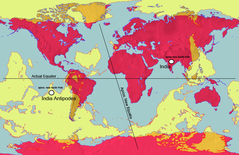
This world map (in red) is overlaid with an antipodal map (in yellow)
showing the antipodes of each point on the Earth's surface.
West Coast
The West Coast of the US in general will suffer an onslaught of changes during the Pole Shift, and those living there need to consider not only each and every onslaught, but the combined effect. First, because the Pacific will shorten and subducting plates will be forced under the coastal plate suddenly and forcefully, heating of the superstrata will occur to an astonishing degree. The rock will actually melt in low lying places.
Thus, valleys over subducting plates are out. Then the tidal waves will assault and where the coastline does not offer an outlet for the water, it will climb up as it has nowhere else to go. Thus, hills and mountain ranges close to the coast are out. Then there are the high winds, or hurricane force, which will occur world wide.
So a safe spot must include being out of the valleys but also out of the wind. Then due to the earthquakes, which will be severe on the significant fault lines that crisscross the West Coast of the US, mountain building will occur which can result in the collapse of caves, even in granite, and renting apart of rock.
Yosemite stands as an example of what can happen. And lastly, forest fires caused by exploding volcanoes, sparks, and lightning storms or perhaps the firestorms that can occur anywhere during the shift, will eliminate the forests as a shelter.
California
California anticipates being inundated, due to the very famous Edgar Cayce predictions along those lines. The state is large, so the many problems befalling it do not necessarily spell disaster for any given family. The major cities along the coast will experience devastation due to earthquakes and be unlivable afterwards. Highly industrialized area will find their surroundings befouled as a result of the quakes.
Reliant on piped water, those in the desert will find themselves without clean water as the ocean inundates inland valleys. The long-term danger in riding out the shift in California, or life afterwards, will be from living near or atop plate boundaries, which will be restless for hundreds of years after the shift.
The volcanoes along these boundaries, even those in Alaska, will waft their volcanic dust along the new prevailing westerlies, which will move them down along the coast, in the direction of the new east. Thus, fishing along the coast will be the best option for survivors, who can return to the coast after the tidal waves have settled.
As California’s geography attests, water has often been trapped in the inland valleys, behind the mountain barriers along the coast, and slowly drained. During the compression of the Pacific, water will wash over these mountains, where ravines or foothills allow the press of water tidal bore, and push up the rivers to flood the inland valleys, which will become an immense flood plain.
After the shift, survivors afloat will paddle about in desperation, as rescue by man will not be forthcoming. The valleys will not drain for some years, by then afloat with the dead bodies of those who were trapped there. Man and beast alike will find themselves squeezed into the mountains to the east, where they will encounter stark desert landscapes poorly suited to supporting hungry survivors.
In the north, California becomes or abuts forestland in foothills or mountains, which offers some safety to those scrambling there from the coast or from farmland valleys that will be inundated. As with all areas, danger from forests set afire from falling firestorms or deluges running waters in force down ravines, exists. Yosemite bears witness to the force of solid rock is subjected to during pole shifts - twisting and pressure upward on one end of a rock strata while pressure downward is applied on the other end - such that solid rock snaps, creating cliffs thou-sands of feet high.
The Sierras show many such scars from the not distant past, as when subduction of plates under California occur, this area is crinkled and compressed. This pole shift will be no different, as the compression of the Pacific will be immense. Thus, such sudden changes in the strata can be expected.
San Diego
A city prized for it’s mild climate and beaches, San Diego will find this proximity to the Pacific its doom. Without mountains as a solid backdrop, waves will wash in and out, over San Diego, as though it were a beach. This will scour the city clean, dragging most of it out to sea and depositing the rest inland as flotsam.
Those seeking San Diego after the shift will be shocked to find it apparently missing. And the remnants will in any case go under water within two years, due to polar melting.
Los Angeles
Los Angeles, the City of Angels, will not fare well during the coming earth changes. Long before the actual shift troubles will beset this city, situated on the Pacific coast and atop many active fault lines. The increasingly severe quakes racking the Earth during this time will escalate to include quakes of a high enough Richter to bring down buildings and bridges in this city dependent upon its freeway system.
Broken gas lines, polluted water lines, and the smog situation made worse by fires in the city will cause a return to riots and police brutality of the past. During the week of rotation stoppage, the crust of the Earth is under severe stress, moaning under this, until the shift causes it to separate from the core and move. During this time, as we have mentioned, the Atlantic is stretched, causing the south-east portion of the US and Caribbean and islands to the west of England to lose some of their elevation, creating flood tide hazard even before the shift itself.
The Pacific likewise has stress, not in a stretch but in a compression. This will cause quakes of a high enough Richter to put Los Angeles into chaos. As the elite in the US are anticipating mobs from LA invading their enclaves higher in the mountains and inland, roads blocked by the military, protecting the elite, can be expected.
Anyone not out of LA by the week of rotation stoppage can anticipate being entombed there, as once the shift starts the flood tide will wash the entire city against the mountain backdrop.
Santa Barbara
The high mountains around Santa Barbara will be safe from the tidal waves during the shift, but after that moment this will be a grim spot. During the week that rotation stops, there will be many who realize that tidal waves can be a factor. Just the legends of the Flood will be enough to start a migration from LA, in all directions.
Even without this, having survived, the mountain tops cannot sustain life and the surrounding land will be under water or salt soggy so that one must migrate inland, and any survivors will not be alone on this trail. Travelers with food stocks will be robbed.
San Francisco
San Francisco is a great tourist attraction, due to the Golden Gate bridge, wine country, China Town, and coastal redwood forests. As with other coastal California cities, it is considered an ideal place to live. This very proximity to the coast is what will doom residents of San Francisco during the earthquakes and Pacific sloshing that will accompany the pole shift.
Situated on the San Andreas and other fault lines, rubble and downed bridges and fires along with a large percentage of the population injured can be expected. So trapped, the residents will find themselves inundated with flood tides so forceful and high that the peninsula itself, all the way to San Jose, will have water flowing over it.
This flood tide will roar through the Golden Gate, clash with the water that has flowed over the peninsula, resulting in roiling water drowning the residents of the many cities around the bay. Survival will be an accident. After the shift, due to the forceful subducting of Pacific plates under West Coast, the bay area will actually be above where it is today, in elevation, even after the melting of the poles.
Water that has flowed inland during the shift will take some time to drain from the inland valleys. However, San Francisco can be anticipated to be a good ocean port for fishing, during the Aftertime, and the oceans will be lush and full of fish.
Arizona
As old rock, not much will happen, even the Grand Canyon remaining unaffected in spite of tempo-rary deluges in the area. During the hour of the shift and hours following, the Colorado River will drain the immense amount of water that will dump on the Rockies, during the clash of water soaked air that will push inland into the Mississippi Valley during sloshing of the Gulf, and similar water soaked air that will push inland into the Sierras during the compression of the Pacific.
Existing drainage routes will serve as the route for this water to rush back to the sea. The Hoover Dam will not survive the Richter 9 quakes, in particular will not survive the heaving and jolting that will go on as the Pacific Plates subducts under the West Coast. Such subduction does not affect only the immediate area, but causes adjustments in neighboring rock strata, sometimes hours afterwards in aftershocks.
We have stated that all river will flood beyond their known flood levels, and that river banks should be avoided, and the Colorado River is no exception. Arizona will be a crowded area going into the shift due to the mystique that many ascribe to this place, particularly Sedona, and thus the poor land and minimal water will be taxed during the Aftertime. Where Arizona rises into the mountains, the highlands offer a better potential for life in the Aftertime.
Phoenix
Life in the desert is tenuous, and where large cities have sprung up, supported by imported water and electricity brought in from afar, residents in cities in the middle of deserts are lulled into thinking that life there is possible even without such support.
Being on stable ground, Phoenix will in the main be standing after the shift, outside of the damage done by hurricane force winds and the possibility of volcanic dust dumping or firestorms dropping from the skies. Those who plan on surviving must think about what they will do after they survive, else they will not long survive. A check into the past, at what did live there and the lifestyle required, can be an eye-opener.
Where Arizona is old rock and has withstood many pole shifts without buckling, such cities as Phoenix will find the hard baked soil reluctant to garden even with torrential and continuous rains. Ground that has been baked for millennia under the hot sun is like brick, as what would not blow away in the wind as dust or wash away in flash floods has hardened.
Phoenix is circled by agriculture in places supported by water piped in from nearby rivers, and with this culture established may react to the increased rains that follow every pole shift with an attempt to produce food for the survivors. The dazed populace will lean heavily on any farms nearby, which will find themselves stripped of any edibles so that sustained agriculture is not possible.
Phoenix, like most cities with high numbers of survivors, will find the human survivors like a plague of locusts, consuming everything in sight. With deserts on all sides, and travel inhibited by broken roads and bridges, travelers trying to escape this plight will likely find themselves dying of starvation before getting to lands that can support them.
Tucson
Tucson, as with the rest of Arizona, is situated on old land, plates that have survived numerous pole shifts without fracturing. As improbable as may seem, the hardened soil, which creates flash floods in the desert, will give this desert area water problems both during the shift and during the almost perpetually rainy years afterwards.
Tucson is surrounded by mountains, which will run rainwater into the lowlands. With rising sea levels pushing back on the rivers, rivers will empty more slowly, and thus flash floods can become lakes. Ensure that your survival sites are situated with this taken into consideration, not in a flash flood runoff.
Where Arizona is beyond the reach of tidal waves, and on high enough ground that it will be above water after the existing poles melt, it will be in the traffic lanes that carry refugees from Texas and Mexico. Mexico will carry refugees from Central America, which will be devastated, and from Mexico City itself.
Texas will find itself on mud-strewn flats, with water-weary survivors looking for dry ground. Without fertile agriculture, Tucson and its vicinity will find that stores of food become wealth, quickly plundered from the weak. This does not have a happy solution.
New Mexico
The desert areas should be considered for what will remain, after the shift, as much as for any other factor. Scorpions, lack of vegetation roots to grow into brush, and rock hard soil. Unless one is planning to live off supplies forever, consider where you place your camp! Desert areas with hard baked soil and scarce water should not be expected to support a large population reliant upon gardening.
Santa Fe
High in the mountains and perched on the Continental Divide, Santa Fe will be subject to high winds and a rugged ride during the shift. The Continental Divide represents to point where subducting plates have pushed, the cutting edge where pushing will begin again during compression.
Thus snapping rock, sudden changes in the angle of the base rock, and stress on all man-made structures such as bridges and roads and buildings can be expected. Survivors will find themselves at a high elevation, but travel through the mountains will be as difficult as it was during the pioneer days, and slow. Wildlife becomes unpredictable during such times, irritable and frantic, and may intrude into settlements.
Due to the depletion of oxygen and a thinning of the atmosphere temporarily, during the shift, survivors may likewise find themselves exhausted more readily and puzzled by this. Take life slow, be cautious, and anticipate a simple and isolated lifestyle after the shift.
Nevada
The high plateaus of the Nevada desert will find their live changed little as a result of the pole shift.
Today, scarcely any food is grown in the hard ground, the populace supported by supplies im-ported into the area. After the shift, those survivor without the knowledge of how to live off the desert will starve, and without pumps to bring water from the aquifers, will likely die from dehydration first.
Reno
Reno is a city that supports itself on gambling and gaming, a playland. The necessities of life are imported, and the populace as well as visitors anticipate and dream about sudden and unexpected wealth, rather than cataclysms. Thus, the populace will be ill prepared for the coming pole shift, and will in addition find themselves inundated with desperate survivors from the West Coast, who will run from a land quaking and sloshing and heaving to what they deem the safety of the mountains.
As the desert can scarcely feed any survivors, they will all starve, unable to travel any distance due to broken roads and downed bridges. Mountain men with survival skills may lead small groups to a semblance of survival, but those tagging along will likely doom even this possibility.
Utah
Where the Rocky Mountains are relatively new mountains, mountain building does not affect all areas equally. The stress of subducting plates being pushed under overlying plates, or compression of land being crinkled as it is pushed horizontally, being distributed to the weaker parts of the mountain range. Thus US states lying in old rock, which gives evidence of not having succumbed in the recent past, is a good indication of safety during the coming changes.
Salt Flats are such places, but are subject without protection to the hurricane force winds that will rip all parts of the globe. Where rock surrounding valleys is smooth, without rough edges indicating recent tears, these valleys may be considered safe in Utah. Existing mountain ranges have drainage patterns that give an indication of where water from temporary deluges will go.
Dry creeks and river beds, gullies with water wash marks, and places where they occasional waterways join with draining rivers. Where water is trapped inland by hardened rock, temporary lakes may form, but due to the overall dryness of the area and high altitude, subject to steady winds, these will not last for long.
Salt Flats
The Salt Flats in the western US are old sea beds pushed high as the west coast of the US has been pushed up and over plates to the west. Such lake beds will surely be soured by the hurricane winds, and the hard flat earth does not invite burrows. These lake beds are surrounded by hills and mountains, many with ravines clearly created when water rushed into the lake beds at some distant point.
The land is dry and hard, formed into rock in most places, and inhospitable. It is permeated with salt, a former ocean bed, and is useless for agriculture. However, the Salt Flats have one advantage during the coming pole shift - the land will not buckle. The Salt Flats have lasted over the eons, though various pole shifts as severe as the pending shift, because they are glued to the same plate as the surrounding mountains, and they will not move or buckle.
Thus, if dome shaped structures can be fixed to the lake beds, so that hurricane winds pass over them, this will be an extremely safe area.
Salt Lake City
Salt Lake City has several strikes against it for survivors, due primarily to the inability of the surrounding local to provide food for the survivors. Where the salt flats are old and hard, offering shelter from earthquakes during the shift, these same attributes make agriculture almost impossible unless soil is trucked in and indoor gardening arranged as an enclosed system. This is possible, but expensive.
The lake itself will slosh about little, during the shift, as it is shallow. However, due to the flat nature of the surrounding land, any water movement will have little resistance, so flooding will flow long distances where it occurs, to over 100 miles beyond the shores.
A height of 300 feet along the shoreline will ensure safety, in a structure that can resist the pressure of the flood tide.
Colorado
Colorado is a relatively safe place but a popular one among many contactees who are flocking there. Although within building mountains, Colorado will experience a push over the lands east rather than an up and down motion as in the past. Eastern Colorado descends into the plains, with various rivers and streams draining from the hills into these plains.
For these two reasons, eastern Colorado will find itself considered a welcome place for desperate refuges from the wetlands below. Those on the plains will look to the hills as water begins to lap at their doorsteps, and head for these hills. As the rivers and streams fill up and roadways are flooded, they will increasingly use boats to move up into the safety of the foothills of Colorado.
Thus, those who have settled along these rivers and streams will find themselves a port of safety for desperate survivors, and should prepare for this inundation of desperation.
Denver
Denver is a popular city, an airport hub, a spot for winter sports, and providing scenery and clean mountain air and water to those situating a vacation home there. Thus, it does not lack for interest, and is already a spot where the rich and powerful will flock when the cataclysms approach.
They will consider Denver, and Colorado, their safe place to camp, but being in the main the type of individual to expect service and attendance, they will not be the best neighbors in the Aftertime. Colorado, and especially Denver, will be a study in sociological tides during the days preceding the pole shift and the months following.
Vicious pecking order battles will ensue among those already assuming they are in control, followed by vicious battles among those wanting to effect a takeover when it is clear that government has collapsed and there will be no repercussions. This will ebb and flow, flaring up and then smoldering under the surface, until these groups have either killed each other off or died from lack of attention to the important aspects of life in the Aftertime.
Serious settlements of good hearted folk would be advised to stay well away from this city and its surrounding enclaves, putting physical barriers between themselves and these battles.
Wyoming
Wyoming lists some of its most picturesque spots in valleys surrounded by towering cliffs or steep hills. Does the appreciative populace or visitor understand how those valleys and cliffs were formed? The eastern slope of the North American continent experiences what might be called tumbling when the Pacific shortens.
Land is being pushed, but does not slide evenly over the plains, it curls under, having been caught, and snaps suddenly, when released by a break in the underlying rock. Thus, the dramatic hills. Those living in Wyoming during the shift should expect a rough ride, but if surviving, will find life afterwards relatively rewarding.
Their climate will improve, the melting poles will not reach them, and the new jet stream will in all likelihood not carry volcanic dust their way.
Idaho
Lying to the west of the continental divide, Idaho will find itself under some compression during the coming pole shift. Mountain building will occur. Having experienced compression and the push east in the past, the rock strata in Idaho represents what has withstood this compression. Land to the east of the continental divide will be subject to this compression, and land to the west of Idaho will experience the greatest heat from the friction of subducting plates. Idaho will be pushed to the east during the shift, riding over the plains to the east.
This ride will terrify its residents, but Idaho will not experience the devastation that earth movements will do to others areas to the east or west. A guide to safety in the state is to look for recent activity, that which has occurred during the past few thousand years. Vegetation does not reveal this activity, but the age of torn rock does. Geologists in the area can also be tapped, as they know areas that have remained the same for eons, and where the surface is showing freshly torn rock.
In these torn areas, prepare to settle in for the ride, that rocky hour, in any area not on the rocky hillsides, but rather on heavy soil which will act as a buffer. Idaho has outlets for heat and spewing lava trapped with the surface outlets the path of least resistance. The many hot springs and inactive caldera will become more active, and residents should maintain a distance from these outlets during the shift itself.
High winds and hot dust from volcanoes in nearby states should also be guarded against. Idaho will fare better after the shift, as the climate will be more temperate.
Oregon
Oregon is within a belt along the coast that will experience subducting, the coast rising up by a thousand feet or more due to this. Other than the danger of hot earth, this is a good spot, both before and after the pole shift. The climate will become more moderate, and the elevation will be well above the rising seas.
Hot earth can be guarded against if one chooses their cataclysm hide-out carefully. Humans during former cataclysms ran to safety from the winds first, as these were the first to arise. Thus they went into the valleys, the low areas, and it is here that the heat from friction in lower plates rubbing is the hottest.
The legends report that those seeking shelter in valleys jumped into rivers to cool themselves, only to find the water boiling. Thus plan on a wind and firestorm shelter above the low elevations in broad valleys, and return to the valleys when the danger is past.
Portland
Cities on rivers will experience the problems they are accustomed to with flooding during the coming cataclysms, but in the extreme. Where the surrounding landscape is hilly, rather than flat, the water can also become vicious, roiling, as it is funneled down gorges, creating swirls as water meets water and seeks the path of least resistance. This puts force behind the water, and buildings already thrown off their foundations by earthquakes, unexpected in land not on any known fault line, will be washed away.
Portland, like many cities located in rolling hills or mountainous sites, may find it is a city washed clean, during the coming cataclysms. However, Portland is fortunate to be snuggled against the mountains so it’s residents can scramble into the highlands away from flood tides, is far enough inland to be free from direct impact from the sloshing of the Pacific, and in a part of the world destined to have a warm climate and be close to ocean fishing in the Aftertime.
However, being downwind from volcanoes, currently north of Oregon but after the shift to the west of Oregon, will put Portland under volcanic dust after the shift. Shelter from this ash, and utilizing the ocean for food, should be in the plan for the Aftertime.
Washington
Washington experiences the same trauma as Oregon, but has additional problems to worry about in the nuclear reservations that their military has seen fit to place in their beautiful country. The populace lives with disease and dread already, so this is nothing new, but during the shift the violent heaving and jerking that the ground will experience will spew buried or capped waste into the air.
This will shower down into a wider area than before, poisoning to some extent those living there. Those who live 30 miles from the nuclear reservations are advised that a 100 mile distance is a better buffer.
Puget Sound
Puget Sound will be flooded past human memory during the hour of the shift, due to water pouring in from the compressing Pacific, which will take time to drain, and water from torrential rainstorms pouring into the sound from the rivers that empty into the sound.
Surrounded by mountains, residents in the area should seek high places but be mindful of tidal bore, which can astonish those unfamiliar with what water will do under pressure and with no place to go but up. After the shift, due to higher sea levels caused by the melting poles, the sound will increase in size, giving better access to the Pacific for good ocean fishing.
Seattle
As all port cities along the West Coast, Seattle will find the sloshing Pacific washing it into pieces. Buildings constructed with only gravity and earthquakes in mind do not withstand being covered by a flood tide, something the engineers did not think of. Foundations erode, and water soaked walls crumble, so that the weak link theory applies and they crash, one by one, often into each other. All cities should be avoided during the shift, due to these types of problems.
Mount St. Helens will activate, violently, during the shift, and spew for some decades afterwards, so living downwind from this volcano will find any survivors struggling against constant dust. Thus, moving to what is now north, toward Canada, or clinging to the coast line which will afford good fishing, is the best option for Aftertime living.
Spokane
Spokane has many advantages, being upriver from the point where the greatest floods from runoff will occur, and at a distance from the Hanford nuclear problems. Tidal waves will likewise not reach this far inland. The greatest dangers come from high winds, which will blow inland from the Pacific as it shortens, and the danger in low lying areas of heat from the subducting plates.
This puts those who would ride out the shift in a bind, between the winds above and the melting rock below, but a careful analysis of the surroundings will show that many spots are protected from the wind, but well up off the valley floors. As to earthquakes, Spokane, Washington, is an example of a city that will find itself not merely shaken to and fro by the quakes that will be experienced world wide, but heaved upward, and then dashed down, as mountain building occurs in the state of Washington during the forthcoming pole shift.
Examine the coastal mountain ranges from an airplane to get an idea of what happens during rapid subduction of one plate under another. Mountain building occurs due to crinkling of the upper plate occur, and this crinkling represents pressure and release.
In addition to the heat from friction that heats low-lands in the upper plate to the point where rock melts like wax, the pressure and release that causes crinkling will result in violent jerking and upheavals, sometimes snapping to create new cliffs or jutting rock.
Those riding on the upper plate during these moments will be heaved skyward and dashed, with scarcely a safe place to cling to. Where the land at the point where a fault line forces one plate above another experiences a violent quake, the plates soon break free of each other and slide. Further inland, where the pressure build is delayed, pressure and release occur over a few moments, rather than a single violent jerking motion. Thus, those mountain building points far from the fault line experience more damage than the fault line itself.
Afterwards, this part of the country will experience a milder climate, but the nearby volcanoes such as Mount St. Helen will create a cloud cover that will make outdoor garden-ing nearly impossible! Plan for a diet of grubs and mushrooms, else learn to garden under cover, with lights generated by hydroelectric power.
Montana
This land with rolling hills and fertile soil in the valleys will be situated closer to the new equator after the pole shift, and being inland from the coasts, it will not experience tidal waves. However, as Montana, is straddling the continental divide, it will experience a wide variety of earth changes during the coming crust shift.
The continental divide represents the point where earth has been pushed, during past crashing and pushing together of the plates. It could be considered the bruising edge, the point where new pushing will occur. All land and mountains to the west of this point will be under pressure to move east, and this is where most of the action will occur.
What lies west of the continental divide has substance, as it has resisted previous pushing, and is not likely to crumble. What lies east of the continental divide has, until now, been relatively untouched, and in this equation will most likely be the place that will give in any land push confrontation.
What occurs when an overriding plate moves across or pushes against an underlying plate depends primarily on what the underlying plate presents. If the land is fairly flat, the overriding plate will go for a ride, with anything on the underlying plate scraped along or crushed underneath. If the land is hilly or mountainous itself, the hills and mountains will be compressed and crumpled, creating a situation where rocks and earth are flying about, tumbling and spewing.
We would advise anyone living just east of the continental divide to move inland until the shift is past, and then return to their homestead, due to the unpredictability of what may occur.
Dakotas
The Dakotas are both subject to potential override, where the land to the west is pushed eastward during rapid subducting of the Pacific plate under the North American plate. This has somewhat unpredictable results, as until the plates are put to the test, just what areas will break and crumble is not known.
The pressure is relative, in that it is not how much pressure exists at any one spot, but whether a nearby area has broken and is on the move. Land, as water, takes the path of least resistance. Thus, should the land to the west break and start sliding over the plains, land under pressure to move, to crumble and push out of the way, to the north or south of this point could move side-ways to take advantage of the pressure vent. An additional worry in flat land is the very real possibility of flooding, with no safe place above the flood.
As was noted during a recent spring melt in the Dakotas, flood waters on flat land produces a huge lake, which can shock residents not accustomed to thinking of themselves as vulnerable in this way. During the torrential rains that accompany the shift, such floods are a given.
Minnesota
The midwestern states bordering Canada will find themselves in an optimal location following the pole shift. With an elevation well above the point that flooding from melted poles will encompass, and in an area that will be unaffected by continental tears, mountain building, or the repeated earthquakes that life on a fault line can bring, these heartland states will find themselves picking up the pieces relatively easily after the shift.
The climate will improve, becoming milder, and the soil in these border states is deep and fertile. The major problem survivors will face is infraction as the date of passage approaches, and militant groups look for new locations to establish strongholds.
If democratic practices are defended, and would-be dictatorships resisted, this part of the world should find itself able to help other parts of the world during the Aftertime, coming from a position of strength. Travel for survivors should rely heavily on small boats, not only because of the network of small lakes in Minnesota, but because the existing drainage of rivers will facilitate travel to almost all parts of the state and neighboring states.
Minneapolis
Minneapolis and St. Paul are positioned where several rivers draining inland lakes, the headwaters of the Mississippi converge. All cities along major rivers will find themselves under several feet of water, washing strong and tearing away foundations such that buildings collapse and become battering rams further down stream.
There are bluffs along such river banks, in particular the Mississippi or to the south toward the Iowa border, where survivors can scramble, and they should be there well ahead of the hour of the shift as rising water will create havoc with roadways and bridges. In that the waste majority of city dwellers will not heard, nor heed, any warnings, they will be in all likelihood drown, reducing the population of Minnesota considerably during the hour of the shift.
Iowa
Lying between the Missouri and the Mississippi rivers, Iowa will find itself under water during the deluges that accompany the pole shift. It will take many weeks for the water to drain away, and due to the continuing rains, will find itself soggy for months and even years afterwards.
As the soil is rich and the land cleared for farming, this will be considered an ideal site in the future as it will have a warmer climate and location central to the continent. It also is considered a benign state, with placid farmers content to reap the riches that the land delivers and with none of the feistiness that the residents of many other nearby states exhibit.
These advantages may doom it to be considered an attractive spot by the group of individuals who consider themselves a carry-on government, so those who would set up housekeeping in Iowa should bear this in mind. Should Indiana fall out of favor, Iowa is not that far distant. However, the likelihood of being under water for an extended period of time will most likely put this spot out of favor.
Nebraska
Nebraska, being a state blessed with rich soil and gentle rolling hills, would seem an ideal location. It lies high enough that it will be spared any inundation from melting poles. It will move into a new climate, warmer than its former climate. And it is relatively unpopulated, in the main a peaceful, rural place. One should not be lulled by this description into thinking that no danger exists, as it does. Eastern Nebraska is flat, and adjoins the Missouri River which will flood.
Between the moving hills on the west, and the flood waters on the east, those in Nebraska will find themselves with few places to go to escape turmoil during the shift. Rivers will flood their banks, even if well above sea level, as the rivers will be backing up from tidal inundations, and rain may be excessive and constant up-river. Any relatively low-lying lands, anywhere in the state, will thus be subject to flooding from rivers and creeks at a distance. Water travels, seeking its lowest level.
The gentle foothills in the west offer shelter from wind and the option of scampering up out of floods, but the torn gullies of the Black Hills should be a warning. These hills move when the Rockies are jerked upward by a shortening Pacific, and will move again, pushing over the flat plains to the east some-what.
Kansas
Consider the nuclear installations nearby. Local pollution will undoubtedly occur unless the US does much better at disarmament. Kansas will be the high ground that drowning survivors from the Mississippi Valley climb to from Texas and Oklahoma and parts east and south. They will be heading not so much for the foothills of New Mexico, which are deemed dry and inhospitable for agriculture and in any case further away, but for Kansas, in the grain belt of America.
Add to this all the survivors in eastern Kansas, who cannot certainly go east across the flooded Mississippi or north into equally flooded country, so must clamber toward the mountains. And what will they do, while passing through the hilly country of western Kansas?
Demand food, demand information on what has happened, and demand supplies that they surely have not brought with them. It is advised that residents of this heavy traffic lane store their goods well out of sight, in bermed spots that appear to be hills, or buried in ravines, and walk about poor and in rags and as befuddled as those passing through.
For those strongly in the mind set of Service-to-Other, this is an opportunity to have a great impact on survivors, advising them, supplying them with seed, or otherwise sending them on their way empowered to help themselves in the mountains or wherever they ultimately settle.
Oklahoma
Land caught between the influx from the Gulf and outflow of swollen rivers is in a pinch. It is not so much the relative elevation of land, during the shift, as the amount of water to be drained from swollen rivers, and the back-wash that these rivers will experience from sloshing in seas or inlets. Melting snow, in the past few years, has put land in the Dakokas under a sheet of water that shocked the residents, as it was an abnormally rapid melt.
The water simply had nowhere to go! It is thus that Missouri will be under water, from the overflowing Mississippi and Missouri Rivers, in backwash from the Gulf. If the water cannot drain, it will move about inland, as those who have lived through floods know. Add to this our statements that Missouri will be under water during the shift, with the exception of the Ozarks. Oklahoma lies between these two water masses, and all except the highest and rockiest hilltops will be awash.
A spot on the map may be called mountains, but only be so by elevation above the neighboring land. We would advise those wanting to survive with certainly, to move into the mountains or foothills of the Rockies, as there one can climb higher if they see that they have misjudged, and not be caught. Alternatively, the Ozarks will offer safety, but will become an island in the Aftertime, trapped away from family and loved ones on the larger mainland.
Oklahoma will find those awash from Texas on their shores, as they will be a shore from the sloshing of the Gulf. Many in Texas will flee north, and the current trend in Texas is to turn the state into a prison camp. All areas that border on the exodus zone should not be considered prime territory, as they will be inundated with frightened and poorly prepared people. If you wish to be a source of strength, a seed bed for renewal, don’t get in the heavy traffic lanes.
Texas
Those who have witnessed tidal bore roaring up a ravine are astonished that water does not seem to respect the relative sea level during those times. What makes the water climb? Water pressure drives water to climb above its level because at the point where the pressure builds, it takes the easiest path. When the force of pressure is extreme, compressing the water at lower levels, the path of lease resistance is taken.
During a tidal wave, this path is away from the bulk of water. A tidal wave moves inland until one of two situations occurs:
Where tidal waves meet mountains, this can result in tidal bore up ravines. Where tidal waves flow inland, this results in a flood tide going hundreds of miles inland. Where the tidal wave finds foothills or barriers, the force of the wave is broken such that it is slowed, allowing a reduction in pressure behind the wave to arrive before the wave moves far inland.
- the level to which it has climbed is higher than the level elsewhere, and the wave recedes, or
- the pressure behind the wave decreases.
But where the tidal wave finds virtually no barriers, due to the land being flat, it becomes water on the move, and this very momentum carries it far inland, and above a height that would otherwise be expected. Water on the move does more than just push forward, it also creates a void behind it. At first, this water is on the move because there is pressure behind it, like sloshing water in the Gulf.
But then, the force of this moving water takes on a life of its own. It has momentum, and moving forward, creates a void behind it, thus drawing the water in the direction of motion, thus continuing the motion. This water on the move is greater than the resistance in front of it, so it continues. For Texas, this means that the water will lap at the foothills of the Sierras, before dying back.
Texas will be devastated by waters sloshing in from the Gulf during the pole shift as well as the rising waters that occur within in the first two years after the pole shift. Being flat land, and low, the Gulf will roll over Texas without opposition, at a height of several feet. This water must go someplace, and will take the path of least resistance.
If the water is flowing most rapidly as it moves over the flat land, then water that would normally move toward mountains or natural barriers will be diverted to a faster moving flow area - the Texas plains. Thus Texas, due to its flat terrain, will get more water overall than neighboring areas. Even the high plains will have several feet of water moving across it, where the coastal areas will have tidal waves hundreds of feet high.
With few tall trees and faced with the after effects of hurricane force winds and earthquakes that will flatten all but new steel skyscrapers, desperate survivors will have few places to go to escape the moving sheet of water, which will drag whatever it engulfs back out into the Gulf on its return.
Dallas
Dallas sits like a jewel in the center of Texas, but will prove to be a jewel out in the open and without protection during the coming cataclysms. Freed from concern about earthquake damage, being away from fault lines, and concerned only with replacing a few windows after any hurricane that might travel inland, Dallas has had few worries.
During the coming cataclysms, Dallas will find itself presented with wind and water changes that it cannot resist, and its residents will be without protection. Water does damage that those viewing film of floods cannot imagine, unless one were viewing the effects of the flood waters as they encroach. Water melts the substrata, as well as presses against foundations not built to resist such pressures.
Thus, unless constructed on solid rock and with thick walls, most structures will lean in the winds and be pushed over by the rising water. Where a high rise does manage to stand above the water, it will become filled with desperate survivors, who increase in number as they manage to paddle to these islands.
The flood waters will take days, and in most cases weeks, to recede. And what, during those weeks, will these survivors eat and drink? Few will survive, and those that do will live with tortured memories.
Lubbock
Lubbock, Texas can expect water to arrive in the streets, during the pole shift. Unexpected floods will wash away buildings which have foundations based on the premise that the ground will always be dry, or only fleetingly dampened by rain.
Thus afloat, those above the flat lands of Texas will find they are clinging to flotsam, and being washed out to sea by a great flood tide that is as aggressive going back out as it was coming in.
Louisiana
Louisiana is among the states affected by the mightily Mississippi when in a horrific backwash, due to its very low lying ground. The Mississippi River will rise during the drenching rains that follow immediately after a pole shift, the ocean waters evaporated into the air during the worldwide hurricane that occurs during each pole shift condensing out of the air in a fury.
The Mississippi will drain a wide area experiencing torrential rainstorms, and will put any bordering land at risk of flood surges, no matter how high the hill. Large amounts of water may pass though, at great speed, and when encountering an obstruction such as a hill, rise up as the path of least resistance.
These flood surges will not be gentle, so escape in a boat, which would capsize and tumble in the roistrous waves, is not likely. Low lying states along the Gulf such as Mississippi and Louisiana, which border the Mississippi where it drains into the Gulf, can expect to be under water.
Baton Rouge
Baton Rouge will unquestionably be devastated during the pole shift. It lies on the edge of a swamp, with the Mississippi River to its back and the Gulf before it. Both waters will rise during the drenching rains that follow immediately after a pole shift, the ocean waters evaporated into the air during the worldwide hurricane that occurs during each pole shift condensing out of the air in a fury.
Even mild tidal waves at Baton Rouge would inundate the city, and the tidal waves that inundate during a pole shift are almost beyond the imagination of man, at least a hundred feet high at a minimum along ocean coasts. All in Baton Rouge at the time of the pole shift will be quickly drowned.
Mississippi River
The Mississippi River will rise during the drenching rains that follow immediately after a pole shift, the ocean waters evaporated into the air during the worldwide hurricane that occurs during each pole shift condensing out of the air in a fury. Rivers that feed into the main rivers emptying a continent will be affected by several factors that will cause flooding beyond what those living along their banks suppose could ever happen.
Flooding today is a comparatively local affair, in the US affecting several states at most. Where one river swells, another is not so affected, and thus the drainage happens more rapidly than it would if all the rivers were swollen. During the pole shift, there will be torrential rains everywhere, on and off, as the clouds are dropping water whipped up from the oceans.
The Mississippi will drain a wide area experiencing torrential rainstorms, and will put any bordering land at risk of flood surges, no matter how high the hill. Large amounts of water may pass though, at great speed, and when encountering an obstruction such as a hill, rise up as the path of least resistance.
These flood surges will not be gentle, so escape in a boat, which would capsize and tumble in the roistrous waves, is not likely. The horrific backwash caused by a Mississippi unable to empty into the sloshing Gulf will reach as far inland as Missouri and Kentucky, increasing the flooding along the rivers that drain into the Mississippi.
Low lying states along the Gulf such as Mississippi and Louisiana, which border the Mississippi where it drains into the Gulf, can expect to be under water.
Mississippi
Mississippi is among the states affected by the mightily Mississippi when in a horrific backwash, due to its very low lying ground. The Mississippi River will rise during the drenching rains that follow immediately after a pole shift, the ocean waters evaporated into the air during the world-wide hurricane that occurs during each pole shift condensing out of the air in a fury.
The Mississippi will drain a wide area experiencing torrential rainstorms, and will put any bordering land at risk of flood surges, no matter how high the hill. Large amounts of water may pass though, at great speed, and when encountering an obstruction such as a hill, rise up as the path of least resistance.
These flood surges will not be gentle, so escape in a boat, which would capsize and tumble in the roistrous waves, is not likely. Low lying states along the Gulf such as Mississippi and Louisiana, which border the Mississippi where it drains into the Gulf, can expect to be under water.
Jackson
Jackson, Mississippi is an example of being in a bad place during the coming shift, as it is on low lying land, nearby a major river, the Mississippi, which will crest early and inundate all bordering lands with rampaging water, and will go fairly quickly under water after the shift due to the polar melt.
Simply stated, any residents who do manage to cling to life during the shift will find them-selves afloat, at best, with safe land a long reach away. Waters draining from inland will tend to wash any survivors out to sea.
Ozarks
The Ozarks will do well in the forthcoming changes, due to their relative isolation from large megalopolis cities and large bodies of water.
They are far enough inland to escape the assaults of large tidal waves, drain down onto nearby land rather than be subject to rapidly rising floods waters gathered elsewhere, and their inhabitants in general are simple folk who have not forgotten how to live off the land.
Arkansas
Arkansas will have safe and unsafe places, side by side. Abutting the Mississippi, which will flood beyond the imagination of those living along its banks, the low lands will experience flooding that will push up along any tributaries that feed into the Mississippi.
But the highlands, which Arkansas has in abundance, will be above the floodwaters and have another advantage. Where many areas will find themselves faced with hordes of hungry migrants, forced from their homes by rising water, the highlands of Arkansas are isolated from large population centers, and thus will escape this squeeze.
Greers Ferry
Being close to the great Mississippi, which will drain a wide area experiencing torrential rain-storms, would put any bordering land, at risk or flood surges, no matter how high the hill. Large amounts of water may pass though, at great speed, and when encountering an obstruction such as a hill, rise up as the path of least resistance.
These flood surges will not be gentle, so escape in a boat, which would capsize and tumble in the roistrous waves, is not likely.
Missouri
During the torrential rain that accompanies the pole shift hour and the hours following, all major rivers will flood their banks to a degree not in the memory of man. When the banks have been crested, the surrounding land becomes the river, with he water moving across flat land in a sheet, toward whatever is the drainage point.
Man is accustomed to thinking of flood waters as relatively stationary, rising up foot by foot and then dropping in a like manner, so that issues of safety and protection of property from the flood are thought of as escape from the rising water. When the press of water upstream or upland is extreme, from a large amount of water, then flood waters are not stationary but move rapidly, tearing structures off their moorings so that more than the water is on the move.
Trash of all manner will be in the swirling waters, headed for the sea across flat land not accustomed to floods at all! The flood will be a moving rush of water, not in its designated place within river banks, but across miles of land so that the whole state of Missouri, with the exception of the Ozarks, may become a river at flood tide.
Kansas City
Rivers that feed into the main rivers emptying a continent will be affected by several factors that will cause flooding beyond what those living along their banks suppose could ever happen. Flooding today is a comparatively local affair, in the US affecting several states at most. Where one river swells, another is not so affected, and thus the drainage happens more rapidly than it would if all the rivers were swollen.
During the pole shift, there will be torrential rains everywhere, on and off, as the clouds are dropping water whipped up from the oceans. Take away the ability of the wide Mississippi to drain the Missouri River, and what would a flooded Missouri become?
A lake, spreading out over the nearby lands, creeping into every low lying piece of land the fingers of the spreading waters could find. When seeking safe places in land high enough to escape water from the melting poles, and far enough inland to escape tidal waves, think in terms of seeking relatively high land to be safe during the pole shift from such flooding.
Illinois
Illinois will suffer after the coming pole shift due to natural reasons and those set in place by man. Where much of the state is farmland, it lies low and will be awash during and shortly after the pole shift due to flooded rivers and the sloshing of water in Lake Michigan.
Lying deep under the city of Chicago are aqueducts put in place by man, as well as many channels above ground, which connect in one manner or another Lake Michigan and the rivers to the south. Man has built these, and man will suffer when the water goes on the move.
Man-made barricades will crumble, and the worst nightmares will ensue. Illinois will be caught in a crisscross of waters during the pole shift, between the drainage pouring down the Mississippi and the backwash that will push this water back and up even into the headwaters of the Mississippi and it’s tributaries, and the canals deliberately dug in early days to allow Lake Michigan to fill these canals for transportation to the Mississippi, there will be endless movement of water across Illinois during the shift and in the hours and days afterwards.
Anyone not expecting to be in a boat, sturdy enough to withstand swirls, undertows, and thrashing waves, may find themselves and all their possessions lost. Survivors will find themselves having to move as the polar melt proceeds, as most of this state is low lying.
Champaign
Champaign, IL as all of Illinois will not fare well either during the shift or afterwards. Being flat land, subject to a number of rivers bordering the state or crossing it, and bordering one of the Great Lakes, it will find that water is moving across it from one direction or another during the shift itself, and then will be inundated to the point of being under water during the polar melt that takes place within the two years following the shift.
Where hills will afford some protection from flood waters during the shift itself, especially if 200-300 feet above the flat land, no comfort should be taken in this safety as the waters will linger on the land, spreading raw sewage about where towns exist and drowning livestock so that disease will surround the hills.
Those who would survive should plan on moving to other areas, if not before the shift, shortly afterwards, by boat.
Chicago
Lying deep under the city of Chicago are aqueducts put in place by man, as well as many channels above ground, which connect in one manner or another Lake Michigan and the rivers to the south.
Man has built these, and man will suffer when the water goes on the move. Man-made barricades will crumble, and the worst nightmares will ensue.
Great Lakes
The Great Lakes are deep, and contain enough water to create havoc along shorelines, but only those shorelines that are composed of lose soil. Any waves inland will soon recede, so encroachment into the bordering land will not be vast. Due to the widening of the St. Lawrence Seaway, the waters will drain more readily, lowering the Great Lakes somewhat, eventually.
Salt water, where it meets fresh, shares itself to the extent the tidal water flows in and out. The Mississippi has salt marshes only along the deltas, as the water from the Mississippi is the greater factor. The flow, thus, is out, not in, except where the tide affected the marshes along the delta.
Thus, in the widened Seaway, salt water will flood the Seaway until it meets the narrow mouth of the Seaway, some miles up the Seaway from where it empties today. It will not travel up in to the Great Lakes. Consider that these lakes today have a force of water, and empty, and will in future, from drainage. This will continue.
One should assume, rule of thumb, when along rivers or inland lakes:
- Take the worst case in memory, of flooding. Raise that water level up again so it has risen not once, but three times. In other words, if the worst case is a 40 foot rise, then assume a 120 foot rise. So this rule of thumb applies to river flooding, but to cover the sloshing that may occur for inland lakes, a different baseline must be taken.
- Inland lakes seldom flood their banks, or drain. Inland lakes may slosh, but are unlikely to rise to the level that rivers will, in that rivers are a temporary store for water, and inland lakes by their nature, a permanent store. But as a rule of thumb one can take their depth, divide by 5, and assume that level of water to be sloshing inland. In every case, then the surrounding land must be analyzed, as to safety.
Each area has different characteristics, and an analysis must be made accordingly. If you are 50 miles inland from one of the Great Lakes, but in any area that has soft soil so that being 100 feet high does not put you on rock, then you may find yourself part of the muddy Great Lake, being pulled back in a back-slosh.
Thus, the variables are endless, and cannot be addressed by ourselves, but must be dealt with by the guidelines we lay out, by those who would survive themselves!
Wisconsin
Wisconsin is central to a number of changes that will leave the state unscathed in the main. Situated near the center of a large plate, the state will experience jolts with minimal aftershocks. Where the St. Lawrence Seaway will tear open, the tear will not directly affect the state or its boundaries.
Mountain building will not occur, and the majority of the state will remain above water during the polar melts that follow the shift. Blessed with gentle rolling hills and rich soil, the state offers protection from high winds and the ability to garden.
Nonetheless, few will migrate to this part of the world, due less to harsh winters than high taxes and restrictive pollution control rules that tend to dampen business and industry, which move where the political climate is friendlier. Thus over-population of this state is not likely to occur.
Madison
Madison, Wisconsin, is the heart of the state, hosting the state government and university system. Surrounded by rich farmland and spared from the industrial endeavors that chose to site along Lake Michigan, pollution from spills and explosions is not likely to afflict the residents during the shift.
The largest problem will be sociological, as being the site of the state government, survivors in the state, who will be many, will travel there demanding assistance. All governments will fail, as roads and bridges and rail lines will be broken, phones and grid lines down, and paper money worthless and uncollectable.
Thus, local communities will be thrown on their own resources, and any semblance of government left in the state capitol driven to barricade itself from the demands of the public. This of course will not last long, as those behind closed doors will either eventually starve or run.
Survivors should not plan on living IN the city, but find rural spots long before the shift and relocate there.
Michigan
Michigan would seem at first glance to be a problematic state, as it is surrounded by water. How-ever, the Great Lakes do not hold the quantity of water that the oceans do, so our warning about tidal wave effects along sea coasts must be modified.
Those along inland lakes such as the Great Lakes should position themselves 50 feet above the normal lake level, and be at least 10 miles from the shore line, to avoid temporary inundations. Where Michigan is also at the end of the St. Lawrence Seaway, which will tear further open during the shift, neither land or bucking plates will affect this state.
Detroit
Detroit, as with most heavily industrialized cities, will be distressed after the shift. Even in locations far inland and away from danger of tidal waves or sloshing water, or relatively safe from repeated earthquake shaking due to being on stable ground away from fault lines, industrialized cities will crumble due to the state of buildings raised when earthquakes were never a consideration.
Old brick or concrete, rotting timbers unchallenged by high winds or present day earth-quakes, and city sewage lines rusted and waiting to crack. In addition to the rubble such industrialized cities will present, there is the issue of pollution, noxious chemicals unleashed and lingering, and contamination of drinking water from sewage. Add to this the prospect of trying to raise or collect food in such an environment, often inhospitable to life.
Where Detroit will not suffer in the same manner as many coastal cities subject to tidal waves or flooding, it should not be considered a place to live after the shift. Survivors should plan on moving, as they will be forced to do so in any case.
Indiana
Eastern Indiana rises into the foothills of the Appalachian mountains, and thus affords some protection from flooding during the shift and the torrential rainstorms that follow for some months after the shift. As with Ohio, desperate survivors will crowd into these hills, and families afloat will arrive at dry land expecting to be welcomed and fed.
A carry-on government has a base in Indiana. Near Kokomo, Indiana, in the hills surrounding this small town, burrowing goes on as the shift approaches. These power hungry elite will attempt to take over any nearby settlements.
Thus survivors in or near Indiana will find themselves defending their perimeter from many onslaughts -hungry and desperate common folk as well as arrogant and angry carry-on government employees.
Indianapolis
Indianapolis lies on the border between land that will be flooded after the existing poles melt, and high ground. It has the added burden of the US plans for a carry-on government to be located near Kokomo, which will not welcome the taxpayers straggling up from Indianapolis, looking for food or assistance or shelter.
Guns will be turned on those who paid for the burrows at Kokomo, and any who refuse to be turned away amicably gunned down without conscience. As an industrial city, with the crop land between itself and Kokomo a mined and dangerous territory and with the crop land to the south under water, any survivors will find they are have few options but to take to floating along the lapping beaches, looking for a hospitable landing.
They will not be alone, as survivors in the great Mississippi valley region will likewise be looking for a landing spot, and survivors in higher ground tired of these approaches likely to be a bristly as the US carry-on government enclaves.
Ohio
Ohio will have a relatively uneventful pole shift, due to its sheltered location nestled against the inland side of the Appalachian Mountains. Problems will ensue in the following months, however, as the rising sea will push inland up from the Mississippi Valley and along the Ohio River.
Ohio’s peoples will find themselves repeatedly moving to escape the rising water, pushed into neighboring lands that might not welcome newcomers. With a broad lake before them, and the Appalachian Mountains behind them, they will have but one direction to move - into the mountains. Where these mountains will do well during and after the pole shift, they will soon become crowded with new-comers moving inland from the rising coast and moving inland to escape the rising waters in the Mississippi Valley.
Thus, those who wish to settle there should establish a place early in the resettlement process and not wait until they are forced to move.
Cincinnati
Situated in the heart of the Ohio River valley, Cincinnati will find itself constantly worried about inundations from one source or another. Even high ridges will find themselves moving from islands at time to being underwater for short periods of time. The rising sea level from melting poles will eventually make the city unlivable altogether.
During the shift itself, the greatest danger comes from local torrential rains colliding with a backwash coming up from the Mississippi.
Survivors will find themselves moving into the Appalachian mountains over time, pushed there by a widening Ohio River that will cut off access in all directions within months of the shift.
Kentucky
Kentucky lies along most of its length along the Ohio River, which will flood into the low lying lands of Kentucky as the torrential rains will be backup up by a Mississippi unable to empty into the sloshing Gulf. What this means for the residents is that they must run for the hills, and if living along the river will most likely not have this opportunity.
Kentucky has a benefit for those living along the Appalachian Mountains, as they live on limestone strata that will minimize the earth-quakes that will shake the world.
Louisville
Cities bridging major rivers will universally have problems during the pole shift, due to torrential and almost continuous rain during and following the pole shift and the backwash caused by sloshing in the oceans and seas. Flooding is often considered a slow and almost benign rising of the water, but when the rise is sudden and the press behind the wave unending, a different scenario unfolds.
City streets, lined by buildings, will funnel the water so that it spews beyond the cities into the surrounding suburbs, a type of tidal bore. Thus, those who have considered themselves safe from flooding can find themselves faced with angry roiling water, far from the river banks.
The rebellious potential of water should be well considered by those wanting to survive the coming cataclysms.
Tennessee
Tennessee lies high enough that it will fall into the land mass along the Appalachian Mountains rising above sea level after the poles have melted. Blessed with till-able soil and a hardy people, the state has a better chance than most to survive the pole shift with self sufficient groups of survivors.
This in and of itself brings problems, as the lack of sunlight will reduce the harvest dramatically, and tensions among the survivors will increase accordingly. When the deer have been hunted to near extinction and the food stocks gone, what then? Where outright starvation is the obvious outcome from the start, survivors tend to mentally adjust to that and it is all over fairly quickly, but when it would seem that surviving the shift has occurred, the mind set is that life should improve, thereafter.
When this does not occur, and many painful choices are presented during a long drawn-out starvation period, periodic confrontations over who should live or die occur.
Knoxville
The spine of the Appalachian Mountains will afford a safe place for those who have lived there for decades and learned to scrape a living from the steep mountain sides. Little industrialization has occurred, with farms and towns separated by winding roads and rocky hillsides, so wildlife and country ways have been left relatively undisturbed.
The danger that living in these isolated areas will present will not be from nature, but from man, who will rush to the hills, the highest hills, when they finally conclude that tidal waves striking the coasts are not as unlikely as they had hoped.
Wandering on foot, hungry and demanding attention, these city folks will be a burden on the shy and self sufficient country folks who live in the hills of Appalachia. Thus such cities as Knoxville, Tennessee may find themselves with urban dilemmas they had never considered.
Appalachia
The Appalachian mountains will be above the water line when all is said and done during this next pole shift, including the melting of the poles that will raise the oceans some 650-700 feet within a couple years after the shift. Where relatively isolated now, those living in these mountains will find themselves increasingly crowded with survivors who will be forced to move inland to escape the rising waters.
The climate will remain temperate, and as the people of Appalachia have often been forced to live off the land, they should fare as well as any during these troubled times.
New Madrid Fault
There has been much made of an earthquake in the recent past long the New Madrid fault line, as this was unexpected, being in a quiescent area, and thus raised all manner of questions regarding the possibility of massive earthquakes in areas presumed to be safe.
Simply put, there are no earthquake free areas, and during the coming pole shift, all parts of the globe will be subject to them, without exception. Thus, individuals living in areas which have never experienced an earth-quake should not presume safety but should take the same steps in preparing for the pole shift that those living atop highly active fault lines take - stay out of old or masonry buildings, and anticipate earthquakes as severe as any that mankind has ever experienced and noted.
Alabama
Alabama is not a location is be situated in during the coming pole shift. Where some areas are far enough inland and high enough to avoid being swamped during tidal sloshing that accompanies the pole shift and the day or so after, there are other factors to be considered.
Alabama is among the states affected by the mightily Mississippi when in a horrific backwash.
Georgia
Low lying lands along the eastern coast of the United States will be drawn below sea level some 150 feet at the start of the pole shift, water rushing in over land pulled down temporarily by the stretch that the sea floor of the Atlantic will experience.
This in combination with the tidal waves that all ocean coasts can expect will wreak havoc on states such as Georgia. Where Georgia has land in it’s headlands that border the Appalachian Mountains, the steady rise of land from coast to foothills will actually encourage the water to rise higher, as it will gain momentum.
Those living in the low lands of Georgia will in all likelihood drown, unless in boats that can deal with wildly sloshing water. Following the shift, these low lands will also steadily go under water due to the melting poles. Those wishing to survive are advised to move.
Atlanta
Southern cities on the East Coast, such as Atlanta, Georgia, at an 800 foot above sea level height, will watch a flood approach. This is due in part to the timing of the stretch and rip, as the stretch will be sustained for the better part of an hour during a time when water will rush from the poles, where it has moved during the stopped rotation, and will have the push of on-coming water behind it as it flows up against the coastline.
Atlanta, stationed between the Gulf and the Atlantic, will also find itself at a place where two floods, both with their own timing of ebb and flow, clash. This has the potential of heightening the water, forcing it up to an astonishing degree, where the clash occurs.
East Coast
Continental rip, which is what occurs during pole shifts rather than continental drift, occurs down the length of the Atlantic Ocean. Prior to the rip, there is tension and consequent dragging down of the coast line on either side. The East Coast of the US south of the New England area will suffer during the pole shift, due not only to the heavy population of the area but also to this general stretching that the plates under the Atlantic during the crustal tension ahead of the shift, with the crust resisting a ripping apart so that the land on the edges of the Atlantic Ocean are pulled down.
This is most intense the closer one gets to the equator, so that the southern states along the Eastern Sea-board of the US will go under water to a surprising degree, bouncing back when the rip occurs. The closer one gets to the Arctic, the less tension there is, due to the position of these point relative to the bulk of the land masses on these plates, which center south.
This will bring the islands in the British Isles underwater, and along the southeastern US too for an astonishing drop in level beyond what the inhabitant think possible.
The New England states will find themselves bouncing up during the shift, due to the quick ripping of the already separating St. Lawrence Seaway prior to the shift, where the southern states will find themselves pulled under the water prior to the shift. The entire peninsula from central Pennsylvania north, will experience a bounce, but being on the edge of this drama, Pennsylvania will have its toes in water but its head above water.
Where tidal waves elsewhere will in general have the potential of rolling a hundred miles inland to a height of 200 feet or more within that buffer zone, for the East Coast south of the New England area, this must be calculated to be up to 500 miles inland where flat land or tidal bore has facilitated water flow.
The land will drop in sea level, during the shift, 150 feet. The water will rise steadily, not in a tidal wave, so that it will take many by surprise. This tension, and dragging down, will not be relieved until the shift itself, so where land might eventually be above water, prior to the sift it will be under water.
Thus, the majority of the populace not well into the Appalachian mountains will drown.
South Carolina
As with all area along the Eastern Seaboard, south of New York City, elevation will not save them from a dunking unless they are close to 1,000 feet in elevation and several hundred miles from the coast. The coastline will be pulled down several hundred feet just prior to continental rip, which will rent the deep Atlantic Ocean rifts further apart. The permanent effect on the coastline along the southern portion of the US will be a drop of 150 feet, below its former level.
For residents unprepared for this, the rise is sea level will be steady, not a wave as in a tidal wave, and will be completely confusing to those unaware of the coming changes. The water will simply rise up to their feet and then over their heads, steadily.
Those in the foothills of the Appalachian Mountains may find their toes only wet, but for safety, go to higher ground and return home after the shift.
North Carolina
More than the resident of North Carolina are looking toward the relative elevation in the taller mountains in their state for refuge. The mountains in Appalachia are no longer a jumble of rocks, but have been worn down over time and covered with forests and glens.
They are habitable, can support crops in places, and have clear rushing mountain streams. It is no secret that some in the elite have selected these spots as hideaways, have purchased land, often at existing resort sites already setup to house the wealthy, and are prepared to guard their fortresses.
Such encampments will soon need a slave labor force, when the supplies run out. Whether still ruled by the wealthy elite who originally purchased them or by their guards, who have little reason to remain loyal to their original masters, the local farming community will be pressed into service, with great brutality.
Consider your neighbors, when finding refuge from the Atlantic seaboard during the pole shift in North Carolinas mountainous interior.
Charlotte
Due to the stretch of the Atlantic in the week prior to the shift, the major cities in the industrial triangle of North Carolina will find themselves pulled down into what will seem like a steady flood tide coming up over their toes and potentially over their roof tops.
The advice to be 100 miles inland and 200 feet above sea level does not apply along the southern portion of the Eastern Sea-board of the US, where we advise being 1,000 feet above sea level. Where the land rises sharply from the Atlantic, there is also little land to buffer against sloshing, so the press of water can add to this altered sea level to wash desperate and shocked residents off their roofs and into a tide that will go back out to sea when the Atlantic Rift rips, releasing tension and allowing the land along the coastlines to bob back up.
Nevertheless, the land drop in this area is expected to be 150 feet below where it is today, and when combined with the 650-700 feet in elevation that the melting poles will put under water for some hundreds of years, one must be at an elevation of 800 feet or more to expect land under their feet in the Aftertime.
The Appalachian mountains afford relief, but in the North Carolina area will be the site of polarized battles between those who would rule as kings and the residents they would have as serfs for their new kingdoms. Our advice, stay away from wealthy enclaves and keep a low profile.
Virginia
Virginia, with it’s rolling hills and country gentleman ways, is a favorite residential area of many who work in Washington DC. It has a mild climate and good soil and water, as well as a foothills terrain. During the coming pole shift, it will become a hell for several reasons. Lying on the coast, and close to the lands to the south that will be dragged down during the stretch leading into the shift, the land in Virginia will go under the water some 150 feet below sea level at present.
The water at first recedes from the coast during rotation stoppage, having moved to the poles, but during the hour of the shift the water rises steadily during the stretch, not in a rush, so many will take to their pleasure craft and be afloat during the shift.
This will bring the residents of Virginia, armed and angry and looking to re-establish their pecking order, into the mountains of West Virginia, where survival groups will have to deal with these unwelcome visitors.
Charleston
Charleston, West Virginia, being buffered on all sides by several mountain ranges, will fare better than cities at the same elevation lying between the Appalachian Mountains and the Atlantic. Mountain building will not occur, as the land is being stretched rather than compressed.
The poverty in the general area will not make this site a favorite of those looking to relocate, however, so the area is likely to be inhabited by those born there during the cataclysms.
Richmond
Seeking to escape the hot earth sweltering under a sun that never sets, during the week before the shift when rotation of the earth stops, those along coastal towns and inland bays on the East Coast of the US will try to escape by boat to cooler places. Richmond has many residents who boat for recreation, the coast a short drive and boating a long tradition among the residents.
The large ocean bay will be some protection from being dragged out to sea during the sloshing that occurs during and after the shift, so many will find themselves afloat after the shift, hungry and seeking to return inland for food.
Those in the city who have survived being dragged down when the Atlantic stretches, and survived the tidal waves that are inevitable along any coast, will find themselves approached by an armada of boats demanding whatever supplies the hapless survivors have man-aged to gather.
Washington DC
In spite of the advantages of being close to mountain ranges in the surrounding states that afford protection from tidal waves and the rising waters following polar melts, Washington DC has issues peculiar to itself as a city. This will become increasingly evident as the pole shift nears and polarization intensifies between those who care for others, the Service-to-Other, and those who are essentially self focused, the Service-to-Self.
Home to the Pentagon and CIA, and to politicians and lobbyists, survivors will find themselves with the worst kind of neighbors to contend with. Accustomed to finding themselves at the top of the heap, giving orders and pulling their resources from the taxpayers who live and labor elsewhere, most survivors will be demanding service from others.
Scarce stores, which will evaporate in days after the shift, will not be replaced from gardens or by hunting, in those used to pampered lives or urban living. Some form of martial law is sure to be imposed quickly, stripping resources from anyone nearby who has prepared.
Maryland
Maryland rises from the sea, it’s rolling countryside and good soil making it an attractive place to live, a commuter’s paradise. These qualities will lure many who live there to remain, during the coming changes. This will be their doom, as when the survivors from Washington DC look about them for food and the slave classes that have been taken from them by a loss of mobility and communications, they will seek to enslave the hapless survivors nearby.
The king-serf class structure will be justified, in their minds, as a return to order and control of government, but will in fact be to place the power elite on top again. Whoever would avoid this enslavement should put enough distance between the elite and themselves to prevent visits or even discovery.
Delaware
As with all lands lying directly along a coastline, the State of Delaware will take the brunt of any tidal waves heading inland from the Atlantic, protecting other states and cities that lie inland.
Nothing will survive, unless it goes afloat and is caught so that it does not wash out to sea in the retreating wave.
Pennsylvania
Coastal areas along the eastern seaboard of the US will experience deceptive inundations during the pole shift. First the appearance of receding water during the stopped rotation when water flows to the poles, then the appearance of further receding as the Atlantic widens, and then a steady and strong return of the water beyond its former height as the water again settles briefly at the new poles before returning to the equator during resumed rotation.
Thus, even without the tidal waves and influence of the melting poles, eastern seaboard locations will be fooled and then inundated by sea water. The mountainous regions in western Pennsylvania, where now considered an area difficult to farm and with industries tied to coal mining in the past, will prove to be a safe place not only during the shift itself but during the Aftertime.
Ocean access will be provided by the St. Lawrence Seaway, which will widen to the extent of becoming an inlet bay to the Atlantic.
The climate likewise will improve somewhat for western Pennsylvania, after the shift. The greatest danger, as with all land bordering the eastern seaboard, will be from survivors moving inland. Where these survivors come from Wall Street or Washington DC, they will have the attitude that they should be waited upon, and will be aggressive in trying to take over any flourishing settlement they discover.
The Amish, farming in this state, will find themselves with numerous unwelcome visitors just ahead of the shift, as these farms are literally within walking distance of urban areas along the coast. During the week prior to the shift, when the Earth stops rotation, lack of services will empty the store shelves, and those who are able will aggressively seek out self sustaining enclaves, which the Amish are known to be.
Moved inland from the coast, these hungry survivors will then be pushed into the foothills by rising water from the land stretch that will precede the shift, and the melting poles that will follow the shift. Thus all mountain land closely bordering seaboard cities will be crowded, without the resources to feed all the survivors.
Pittsburg
Pittsburg’s greatest danger during the hour of the shift will be the river coursing through the town. A strong and well established drainage in an area not subject to mountain building will find itself utilized aggressively to drain the deluges that will fall during the shift. Hurricane force winds, passing over ocean water, will pick up water tonnage and drop this suddenly in horrendous down pours when updrafts along mountain ranges occur.
Those who have not witnessed rampaging water, moving with great force when under pressure from water upriver creating water pressure that seeks a release, will be shocked to watch the speed and height that such raging water can attain.
Those along the headwaters of the Ohio, where it passes through ravines in well established drainage conduits, will be advised to stay well away from and above this anticipated flood.
Philadelphia
Philadelphia considers itself a coastal, as well as a river front town, due to it’s location along a river emptying into the Atlantic nearby. Where this location helped Philadelphia develop in its early days, this dual access to moving water will be to its detriment during the pole shift.
During the hour of the shift and the hours following, there will be torrential rains swelling the rivers, as well as tidal waves roaring up the bay. The clash of these waters will come near Philadelphia, with the effect that the city streets will be inundated, with housing collapsing and debris crashing about in the waves. With ocean ships afloat in the streets, even high rises cannot be considered safe, as they can sustain collisions and collapse.
This is not a safe city to ride out the pole shift, as few cities frankly are.
New Jersey
All areas along the Eastern Coast will have to deal with tidal waves as a fact they cannot discount, during the coming pole shift. No wall will be strong enough to resist the weight of water that will rise up, 100 feet high, in a steady flood tide, nor are there walls in place today constructed with that in mind.
High rise buildings with doors and windows and sewage connections will do more than flood, on the lower floors, they will crush and drop, as the water will create uneven pressure on outside walls, pressure they were never expected to have to resist. New Jersey does not have the elevation or distance from the coast to assure safety.
New York
Being positioned close to the New England states, which will experience a bounce up as the St. Lawrence Seaway rips further apart, just prior to the shift, New York State will be relatively safe from flooding from the Seaway. As with Canada on the opposite side of the Seaway, the release of tension when the Atlantic and the Seaway rip will allow bordering land, light in nature, to lift.
Flooding will come in from the coast, where the usual warnings about tidal waves are in effect. Stay inland at least 100 miles, be 200 feet above sea level, and consider tidal core or flooding of local rivers overwhelmed by torrential downpours or sloshing of local lakes.
The finger lakes, created when the land was stretched during the creating of the St. Lawrence Seaway in the past, will if anything deepen, allowing the water level to temporarily drop, when the St. Lawrence Seaway once again is pulled apart.
New York City
Heavily populated areas have several drawbacks during times of crisis such as the coming cataclysms will bring. However well prepared a given family may be, they are never prepared for what their neighbors will bring to them. New York City is one of the most heavily populated areas, and by being a coastal city, has additional strikes against it.
Thought the Atlantic will recede at first during the pole shift, due to the Atlantic widening and the waters having in general flowed toward the poles when the Earth’s rotation stops, wave action and reaction will find all shorelines bombarded with sloshing water at some point.
For many, on islands along the coast supported by a system of bridges that have been torn apart, they will have no escape. Tall buildings will bash into each other during the seemingly endless earthquakes, which they were scarcely designed to with-stand. Fires and the howls of the injured and desperate make travel through such a devastated area literally life threatening.
Those who stay in New York City during the coming cataclysms are either ignorant of what is about to occur, courageous, or harboring a death wish!
Niagara Falls
Niagara Falls will split during the widening of the St. Lawrence Seaway, as will all natural and manmade barriers between the Great Lakes and the Atlantic. This will change the level of the lakes, and the drainage patterns, to some degree, depending upon the level of bordering land and the ocean tides.
Salt water will be detected all the way up to Lake Michigan and Lake Superior, which will appear to be the fresh water lakes they are now. Niagara Falls appears dramatic only because the water way spills suddenly, rather than gradually, and being shattered and spread during the widening of the seaway, the falls will become merely rock walls along the new course of the waterway.
Thus, the great seaway will become a mode of travel, and cities along this course such as Buffalo and Hamilton can anticipate being travel stops and point of commerce among survivors.
New England
The tiny New England states are grouped at the end of what will become increasingly a peninsula of land, due to the widening of the St. Lawrence Seaway and the melting poles. The land is rocky, and will rise some 450 feet by our estimate above the current level due to the land being freed from its current connections during this continental rip.
During rotation stoppage, the Atlantic will be stretched, causing land along the southern East Coast of the US and islands such as Scotland and Ireland to drop some 150 feet below the waves. But at the combined ripping of the St. Lawrence Seaway and Atlantic rift, this peninsula of land which is currently called the New England states will be allowed to find its level based on the natural relative gravity of the land.
The land will bob up, some 450 feet above the current level. Nevertheless, due to polar melt to occur over the two years following the shift, this rise will be lost and the coastline actually going under the waves some 200-250 feet beyond the current beach level. Thus, those with homes 250 feet above the coastline might find themselves on the beach. However, to be safe during the shift, our precautions of being 200 feet above sealevel and 100 miles inland should apply.
Sloshing in the Atlantic, and unpredictable water movement into and out of the St. Lawrence Seaway, will result in terrifying moments for those any nearer to the coast. Return to the coastline after some days have passed, and the water seems to have settled into tides that are predictable.
Connecticut
As part of the New England complex that will benefit from the St. Lawrence Seaway ripping open, Connecticut will have a higher sea level after the shift than it enjoys now. However, leading into the shift, it will be subject to waves from the sloshing Atlantic that will drown the coastline. Residents hoping to find their homes above water after the shift should leave, moving inland for the shift itself, and then returning to the coastline to pick up the pieces.
Homes at an elevation of 500 or more feet will be the only ones remaining after the poles melt. However, ocean fishing, an occupation of the residents today, will continue to be a source of food for the survivors, and the climate should, if anything, be milder than today.
Vermont
The New England states will do surprisingly well, in spite of the St. Lawrence Seaway tearing open. Continental rip, which happens along the African rift valley as well, is not as traumatic as subduction or when plates press into each other. It is a release of tension, allowing a stretch to lose its grip, and thus the land will pop up a bit, increasing elevation.
The climate will remain steady, temperate with cold winters, so will not hold surprises for the residents.
Back to Contents
Safe Locations - The Pole Shift
Did an Ancient Magnetic Field Reversal Cause Chaos for Life on Earth 42,000 Years Ago?
The study links new, detailed data about Earth’s atmosphere to a series of unfortunate events that occurred around the same time

My research on ancient human past events and human history have shown that there is not telling the truth at all about our ancient past, why? This article talks about a great earth poles shift that will move the south pole north and the north pole south and everything else, the land, the oceans will have to shift also, what will this mean for the human race? Of course, the great minds of the world ARE SAYING NOTHING ABOUT THIS SHIFT! Why? What is causing this to happen? Has something like this happened in our ancient past? The Human record shows that it has happened many times in fact because the ancient Maya's and the Sumerians have recorded history about a great Planet and (Solar System) call "Nibiru", Planet of the Crossing" and Planet-X, which may be the cause of this great pole shift. But one thing for sure we as a human being must be ready for any great change because our race has been through this before and we are still here.

No comments:
Post a Comment